If you live in an area of the country that doesn’t offer any options for (real) winter mountain biking, the coldest of the four seasons can drag on depressingly. Fortunately, there’s a place to get relief if you’re suffering from singletrack withdrawal symptoms––you just gotta head south!
For riders living in the Midwest, soil types can make riding in the winter impossible due to freeze-thaw cycles and frequently wet conditions. These trail surfaces get destroyed if ridden on in the winter, making even the best winter riding gear a moot point.
But in the mountains of the Southeast, hundreds of miles of trails are rocky, sandy, and well-maintained all winter long. Even better, the temps there are relatively mild, with snowfall being rare in lower elevations.
We’ve put together a list of some primo winter MTB riding in the Southeast, each with some excellent camping options if you’re traveling on a budget or just trying to get some forest relaxation.
Alabama
Coldwater Mountain – Anniston, AL
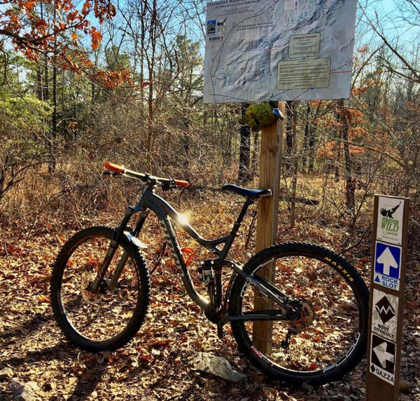
Gazza Trail at Coldwater Mountain. Photo Credit: @Comparedtopisgah, Instagram
Located just miles from downtown Anniston, the Coldwater Mountain trail system has 35-40 miles of purpose-built singletrack with trails for every skill level. If you park at the top trailhead, there are plenty of beginner trails that meander through the forest over a mostly sandy trail bed with option lines for a few little rock features here and there. As you ride deeper into the system, you’ll find rock-tech that borders on ridiculous, starting with the Rock Slot Trail and into the Gazza Trail. If you make it through Gazza’s intense gardens of rock, you’ll have the option to bomb down Bombdog Trail, a blindingly fast, big-bermed, and jump-strewn downhill trail.
If you love jumps, berms, downhills, and riding a ridiculous amount of rock, Coldwater Mountain is where it’s at! The trails are well-marked and easy to navigate here, so it’s perfect for getting a quick ride in if you’re pressed for time. There’s even a National Forest nearby with camping, along with plenty of perfect post-ride grub to be found downtown.
Georgia
Pinhoti Trail – Dalton, GA
The Pinhoti Trail is a 335-mile long trail that runs from Central Alabama all the way to North Central Georgia. The northern section can be accessed just 5 minutes off the exit for Dalton, GA, which has plenty of post-ride options for eating after a long day in the saddle. The trail is technical and rocky, but picking your lines wisely makes it mostly manageable. The riding feels very similar to some of the trails at Coldwater Mountain in Alabama.
This section is an out-and-back, and if you take it all the way to the rock overlook around the 12-mile mark, you can expect a solid 6+ hours of ride time, so plan your daylight and pack accordingly!
Tennessee
Raccoon Mountain – Chattanooga, TN

View of Downtown Chattanooga from Raccoon Mountain. Photo Credit: @Comparedtopisgah, Instagram
The private campground that’s close to the trailhead at Raccoon Mountain is the perfect place to serve as a hub for checking out all the trails in the area. Primitive tent sites are very reasonably priced and peaceful, placed next to a babbling creek and across the road from the RV sites. There’s also a nice warm bathhouse for post-ride showers (so heavenly in the winter). The campground is only 15-minutes from downtown Chattanooga, and there are multiple trail systems around the city. You can even hit the aforementioned Pinhoti Trail in Dalton, GA, which is only a thirty-minute drive to the south.
Raccoon Mountain is technically a hydroelectric power plant with around twenty miles of mountain bike trails running throughout the mountain. There are multiple loops at the top of the mountain, along with two main trails that run up the mountain from the boat ramp parking lot at the bottom (one of the best places to park if you love to end your rides with a huge downhill).
The trails are intermediate to advanced for the most part, with some serious rock garden sections, small bridges, rock drops, and rollercoaster singletrack. There’s even a chunky freeride section over massive rock boulders for huge rock drops and rollers. Easier riding can be found at the top on loops like Switch Yard Trail, which still offers unique views of the powerplant equipment that looks like something straight out of a sci-fi movie.
While the trail bed is mostly rideable in the winter, there are times it might be too muddy, so if it rains significantly, you’ll want to give the trails a day or so to dry usually. Also, note that the gate for the road leading to the top parking lot closes at dark, so in the winter you’ll want to get back with plenty of time to spare so you don’t get locked in. Parking at the boat ramp prevents this issue.
Windrock Bike Park – Oliver Springs, TN
Is shredding downhill your jam? Is there no line too steep for you? Then you need to ride the rock! Windrock Bike Park, that is. This place is not for the faint of heart, featuring some of the most insanely steep, rock-ridden gravity riding east of the Mississippi. Shuttles run up the mountain rain or shine from 10 am to 5 pm in the winter, and they’re open year-round. Unlimited daily lift passes run $40, unlimited winter season passes run $325, and you can even rent a sweet downhill rig for the day for only $130. They never sell-out, and you can book online or at the will-call window at the Windrock General Store.
Oh, did we mention they also have a campground there? It offers team and group housing, cabins, RV sites, Yurts, and primitive campsites, along with bathhouses and a few pavilions for group events.
North Carolina
Wilson Creek, Pisgah National Forest – Mortimer, NC

Waterfall on Estes Mill Trail in Wilson Creek. Photo Credit: @Comparedtopisgah, Instagram
If you’re seeking a winter wilderness adventure, you have to check out Wilson Creek! Nestled deep within the Grandfather District of Pisgah National Forest, just 30 minutes from Morganton, NC, the area has some of the Southeast’s best primitive camping spots. The campground in Mortimer is closed during winter, but the main forest service road (NC 90) has numerous free primitive campsites that can easily accommodate multiple vehicles for a small group trip. Some are relatively close to the gravel road, while others offer a bit more privacy along with peaceful creekside sounds.
While the camping is stellar there, the real reason to visit Wilson Creek is the mountain biking for those who love a ludicrous level of gnar. Make no mistake, the vast majority of singletrack here is highly technical––rocky, rooted, and full of creek crossings––on top of brutally steep climbs that will make you question your sanity. That said, if you have newer riders in your pack, there are a couple of trails for those who aren’t as keen on technical trails.
For the most gnar possible, check out the Yancey Ridge Loop. You’ll get a heavy dose of gravel road climbing to warm you up (like most of the rides here), including some soul-crushingly steep sections. But once you make it to the singletrack, you’ll be rewarded with one of the sickest rolling ridgelines filled with blindingly fast downhill sections to full-out rage on.
Did we mention Wilson Creek is perfect for folks who love wilderness adventures? Well, that includes the singletrack too. The trail corridor on the Yancey Ridge trail can be downright claustrophobic, with corners and drops concealed by rhododendron and mountain laurel that constantly grab at your brake levers, adding another element of wild fun.
For a more mild ride, the Upper Wilson Creek Trail (aka 21 Jumps) is your best bet. The trail bed is less rocky and has fewer technical sections. As the name implies, there are a ton of jumps at the start of the singletrack section, but most of them are fairly small, and all can be rolled slow if going for big air isn’t your thing.
You won’t always have cell service in this area, so using an app like Trailforks that allows you to pre-download maps is a must. This area can be difficult to navigate, with missing trail signs in some places, so it’s essential to read the trail descriptions in your GPS trail app carefully. It’s also a very good idea to bring a paper map from Pisgah Map Company, as the rides here can be many hours long, easily enough to fully drain a cell phone battery, especially when using GPS and taking pictures.
We hope you get a chance to ride one (or all) of these incredible areas soon! When you head out on those new trails, the easiest way to stay on course is to mount your phone using one of our RokLock bike mounts to keep your GPS app in view. And don’t forget, we love seeing the places you ride, so be sure to tag us on Our Instagram and let us know which trail (or trails) you visited!